Road Closures For Great Birmingham 10K

On Sunday 3rd May 5000 runners will pound the streets in the Great Birmingham 10k. But that means lots of roads are closed...
Birmingham City Council, in conjunction with Morrisons Great Run, are organising the Morrisons Great Birmingham 10k - a mass participation run starting at approximately 10:00, which is expected to attract upwards of 5,000 runners. The run will start on Jennens Rd and finish on Broad St between Paradise Circus and 5 Ways Island.
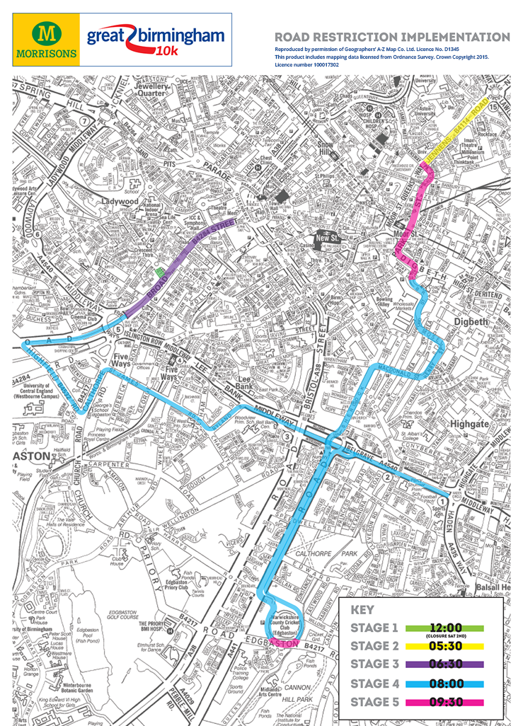
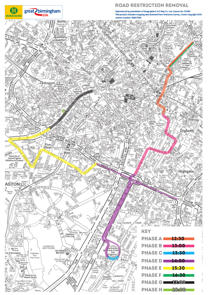
Before and during the run, it will be necessary to implement a number of road restrictions (please see list below) along the route between 05:30 and 18:00 these have been agreed with Birmingham City Council and will be implemented in a number of phases (traffic restrictions from 05:30 – 09:30; road restriction removal from 12:30 – 18:00). The times are approximate and the road restrictions will NOT affect the access of emergency vehicles.

Reopening of roads will be done in a structured manner following the last runners in the event. Event infrastructure will be removed and roads cleansed ahead of the reopening.

It is asked that you to help ensure that there is a safe route for the runners by parking on your property, if you are able to, or on a side street and not on the course route from midnight Saturday 2 May until the event is finished.
Cars found parked on the day of the event on the course will be removed to an adjoining street, and could be subject to a parking fine so please remove your vehicle before the closures come into effect.
LIST OF ROADS AFFECTED
- Jennens Rd (Start)
- James Watt Queensway from Dale End to Jennens Rd
- Park Street
- Digbeth High Street
- from Park Street too Rea Street
- Moat Lane
- Bradford Street
- from Moat Lane to Rea Street
- Barford Street from Sherlock Street to Bradford Street
- Moseley St from Barford St to Charles Henry St
- Charles Henry St from Moseley St to MacDonald St
- MacDonald St from Charles Henry St to Wrentham St
- Sherlock St from MacDonald St to Belgrave Island
- Belgrave Island
- Pershore Rd from Belgrave Island to Edgbaston/Priory Rd junction
- Edgbaston Rd from Pershore Rd/Priory Rd junction to Russell Road
- Lee Bank Middleway - Ring Road westbound towards Five Ways only (Belgrave Middleway and Lee Bank Middleway) from Haden Circus to Wheeley’s Road Calthorpe Road
- Ryland Rd
- St James’ Road
- Calthorpe Rd from St James’ Rd to Highfield Rd **
- Highfield Rd from Calthorpe Rd to Hagley Rd
- Hagley Rd from Chad Rd to Broad St (west bound only)
- *Old Sheepcote St from Broad St to Sheepcote St
- Broad Street - whole length
* Road closure will be from midday on Saturday 2 May
** Access to Morrisons store via Five Ways, Calthorpe Road, Greenfield Crescent and Harborne Road Hagley Road - from Broad Street to Highfield Road (out of city side)


